AE01201V
A report on the heritage impact assessment related to the Exxaro Matla Project near Kriel in the Mpumalanga Province
Summary
Archaetnos cc was appointed by GCS to conduct a heritage study for the Exxaro Matla Project. This is for a coal mining operation on various farms, close to Kriel in the Mpumalanga Province. The project will be a coal mining operation, including opencast and underground mining as well as associated infrastructure. Thee mining right area covers approximately 22 000 ha.
The Scope and purpose for the survey were to do an archaeological and heritage survey and assessment according to generally accepted HIA practices endorsed by SAHRA and ASAPA. In the process the aim was to identify all objects, sites, occurrences and structures of an archaeological or historical nature (cultural heritage sites) located on the property and to assess the significance of these cultural resources in terms of their archaeological, historical, scientific, social, religious, aesthetic and tourism value. These were to be documented, and the possible impact of the proposed development on these was to be described. In addition suitable mitigation measures to minimize possible negative impacts on the cultural resources were to be proposed.
Cultural Resources are all non-physical and physical man-made occurrences, as well as natural occurrences associated with human activity and include all sites, structures and artifacts of importance. Graves and cemeteries are included in this.
It has to be mentioned that it is almost impossible to locate all the cultural resources in a given area, as it will be very time consuming. Developers should however note that the report should make it clear how to handle any other finds that might occur. In this particular case there were certain areas with dense vegetation which made archaeological visibility difficult. In some instances gates were closed making it impossible to view certain areas.
Aspects concerning the conservation of cultural resources are dealt with mainly in two acts. These are the National Heritage Resources Act (Act 25 of 1999) and the National Environmental Management Act (Act 107 of 1998).
According to the National Heritage Resources Act the following is protected as cultural heritage resources:
a. Archaeological artifacts, structures and sites older than 100 years
b. Ethnographic art objects (e.g. prehistoric rock art) and ethnography
c. Objects of decorative and visual arts
d. Military objects, structures and sites older than 75 years
e. Historical objects, structures and sites older than 60 years
f. Proclaimed heritage sites
g. Grave yards and graves older than 60 years
h. Meteorites and fossils
i. Objects, structures and sites or scientific or technological value.
A Heritage Impact Assessment (HIA) is the process to be followed in order to determine whether any heritage resources are located within the area to be developed as well as the possible impact of the proposed development thereon.
The National Environmental Management Act states that a survey and evaluation of cultural resources must be done in areas where development projects, that will change the face of the environment, will be undertaken. The impact of the development on these resources should be determined and proposals for the mitigation thereof are made.
The evaluation of heritage sites is done by using the following criteria:
• The unique nature of a site
• The integrity of the archaeological deposit
• The wider historic, archaeological and geographic context of the site
• The location of the site in relation to other similar sites or features
• The depth of the archaeological deposit (when it can be determined or is known)
• The preservation condition of the site
• Uniqueness of the site and
• Potential to answer present research questions.
Before doing the physical survey, a survey of literature was undertaken in order to obtain background information regarding the area. This was followed by the field survey. People from local communities are also interviewed in order to obtain information relating to the surveyed area.
All sites, objects features and structures identified were documented according to the general minimum standards accepted by the archaeological profession. Co-ordinates of individual localities were determined by means of the Global Positioning System (GPS).The information was added to the description in order to facilitate the identification of each locality.
The surveyed area is mostly disturbed due to previous human activities on the site. This includes mainly agricultural activities such as ploughing and the planting of maize and other crops, as well as grazing. Certain areas are covered by grass, which were of different lengths. Some plantation areas (blue gum, poplar, wattle etc.) are also found, in certain cases reasonably inaccessible.
The Matla Power Station dominates the landscape and current mining operations and infrastructure are also to be found nearby. The topography of the area consists of rolling hills with a gentle slope. Declinations are found close to rivers. The main water source is the Riet Spruit which runs from the south-west to the north-east. A number of pans are also found.
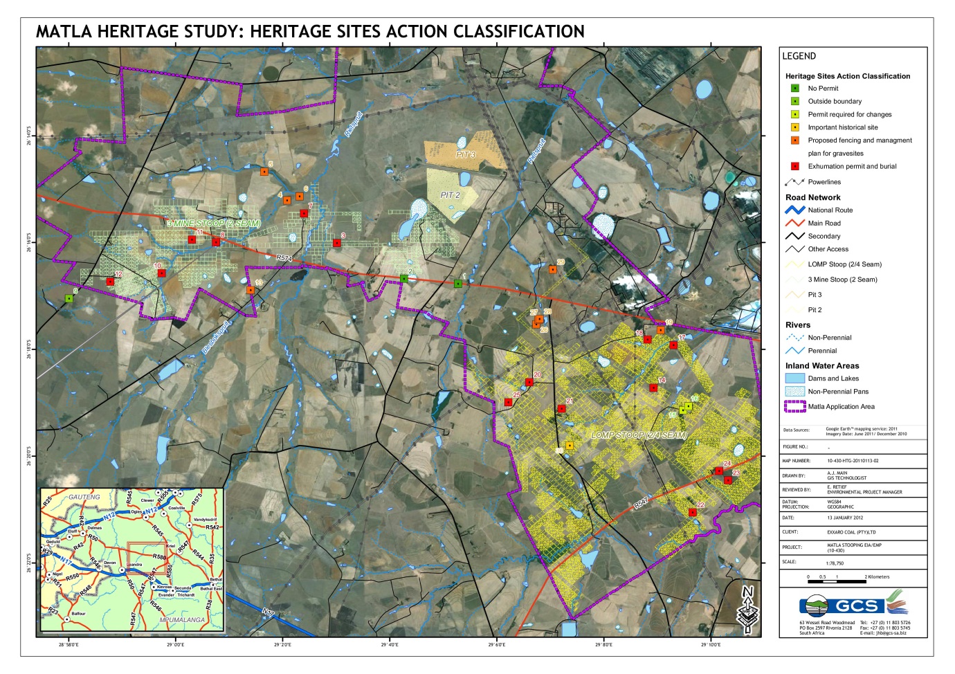
The fieldwork undertaken revealed thirty sites of cultural heritage significance. Twenty-six of these are given a rating of high cultural significance, two medium and two low. The recommended mitigation and management measures for these are summarized as follows:
1. For site numbers 1 and 2 (house ruins), this report is seen as ample mitigation and the sites identified may be demolished without a destruction permit.
2. Site number 9 falls outside of the project area and should only be taken note of.
3. Sites number 15 and 16 may be re-used for offices or another appropriate purpose. For any changes to be made to these structures a permit needs to be issued by the Provincial Heritage Resources Agency (PHRA) of Mpumalanga. As these buildings falls within the underground mining area, it may be damaged during mining activities. Therefore the recommendation is that both should also be documented during a phase II investigation in order to preserve basic information. Should any damage then occur, the mine may apply for a demolition permit from the Mpumalanga PHRA.
4. No visible evidence of site number 30 (Battle of Bakenlaagte) was found and therefore the site cannot be preserved. It however remains an important part of the history of South Africa and should be commemorated, perhaps by placing a plaque next to the road, as close as possible to the site. It is also recommended that, should any artifact related to the battle be unearthed or found during activities on site, an archaeologist should immediately be contacted to investigate the find.
5. The fencing and management plan option for graves is recommended for sites number 4, 5, 6, 13, 19, 26, 27, 28 and 29. This would be possible should there be no direct impact on the graves. The plan will have to be approved by the Burial Grounds and Graves Unit (BGG) of the South African Heritage Resources Agency (SAHRA).
6. However, the mine may decide upon studying the risk assessment table that it would be better for their operations to have these sites exhumed and relocated. This may be allowed upon SAHRA approval.
7. The option to exhume graves and have the bodies reburied is usually only allowed if there is a direct impact on the site. This option is recommended for sites number 3, 7, 8, 10, 11, 12, 14, 17, 18, 20, 21, 22, 23, 24 and 25.
8. Due to constraints indicated in this report it is possible that all heritage sites may not have been identified. Such sites found later on should be handled in accordance with this report which inter alia includes summoning an archaeologist to site to assess these. It should also be noted that the subterranean presence of archaeological and/or historical sites, features or artifacts is always a distinct possibility. This includes graves. Care should therefore be taken when development commences that if any of these are discovered, a qualified archaeologist be called in to investigate the occurrence.
9. It is difficult to do a sensitivity assessment of the area as heritage sites usually only covers a small amount of land. One should be on the lookout for clumps of trees or grass within ploughed fields which may indicate graves or ruins. In this area it seems as if graves were particularly found in plantations, close to houses or ruins and in wetland areas and therefore these areas will also have a high sensitivity rating. The problem is that a few graves were found inside of ploughed fields without any vegetation around it – this basically means that one can found graves anywhere. The bottom line is that the nature of heritage sites is such that predicting its locations is almost impossible.
10. Once the recommended mitigation measures have been implemented, the mining activities may continue.
Report by
Dr. A.C. van Vollenhoven (L.AKAD.SA.)
Images